Elevation API
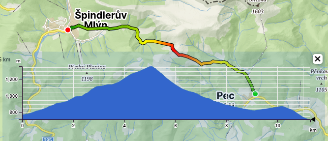
The function returns the elevation for a given point or a set of points (up to 256 at once – max. within a 1×1 degree range). It can be used, for example, to obtain the elevation profile of a route.
For specific usage examples, refer to the Tutorials. We have a simple demonstration for getting elevation at a point and a more complex example of displaying the elevation profile for a planned route.
Function Description
- Elevation – the function returns the elevation for input points
Technical Documentation
https://api.mapy.cz/v1/docs/elevation/
The technical documentation provides an exact description of input and output parameters, default values, errors, and other details.
Input Parameters
| positions | Up to 256 points (coordinates) for which we want to determine the elevation. Points should be close to each other (max. within a 1×1 degree range). |
| lang | Preferred language – does not affect this function |
Return Values
The function returns an array for each input position
| elevation | Elevation in meters In case we do not have elevation information for a given position (see elevation model below), for a query on a single position, we return a 404 error, and for a query on multiple positions, we return -100,000 for that position. |
| position | Coordinates for which we calculated (corresponds to the input coordinates) |
Elevation Model
Our elevation model covers almost the entire world, except for areas around the North and South Poles.
The model is a combination of several elevation models with varying accuracy. For the world, we use a global model, and for Central European countries, we use national models created from highly accurate lidar data. We continuously add similar models for European countries, continually refining the data.
Note, this is still a model with varying accuracy, and height data may not necessarily correspond to reality.