Atribution
Or in other words, acknowledgment of authorship, proper logo attribution, and copyright notice.
Terms and conditions require that the Mapy.cz logo and copyright text be correctly displayed when using the Mapy.cz REST API.
When Using Map Tiles

When displaying the map, it is necessary to:
- Display the colored Mapy.cz logo with a white border
- The logo must be placed in a visible area above the map and in the same (or larger) size as in our tutorials. That is, the minimum height of the logo is 28px. The logo must be the same size or larger than other logos used above the map.
- The logo must be clickable, and the link should lead to https://mapy.cz/.
- You can use this URL directly for the logo: https://api.mapy.cz/img/api/logo.svg.
- Alternatively, logos are available for download here: https://o-seznam.cz/ke-stazeni/loga/.
- Include the text copyright notice: “Seznam.cz a.s. and others”
- with a link to https://api.mapy.cz/copyright.
- The copyright notice must be placed in a visible area above the map.
- You can easily copy the correct attributes from our tutorials by copying the code.
- The current parameters for the copyright text and the URL address for the logo are returned by the function tile.json.
When Using Other Functions
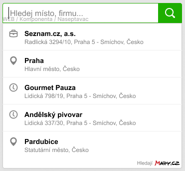
When using other functions (geocoding, route planning, etc…), you need to:
- Display the colored Mapy.cz logo with a white border
- The logo can be accompanied by the words “Powered by Mapy.cz”, “Hledají Mapy.cz”, “Plánují Mapy.cz”.
- The logo must be placed near or directly within the search/planning dialog.
- The minimum height of the logo is 10px.
- The logo can be clickable, and the link should lead to https://mapy.cz/.
The Static Maps feature handles attribution automatically, so there is no need to address it. The JS Panorama component does the same.
Note: If the above functions are used in close connection or directly above the map (with proper attribution as mentioned above), the logo may not need to be re-displayed for these functions.